A global networking gateway bridging the Americas with the rest of the world via a teleport and terrestrial networks.
- 24/7 manned, 3.4-acre facility southwest of Houston, Texas, (29.58⁰ Lat/-95.50⁰ Lon) a strategic location covering the Americas, Europe/Africa, and Australia, including critical maritime and flight routes.
- 15,000 square foot building with customizable floor space for data center, NOC, office, and warehouse capability.
- 14 fixed & 2 mobile C & Ku antennas, from 2.4m to 12m, accessing key satellites from 221ºE to 330ºE (30ºW to 139ºW) with active US FCC C-Band Broadcasting Licenses.
- Available for Co-location, Diversity and Disaster Recovery, Mission Critical solutions from 1RU to Multiple Racks; Controlled Access and Secured Private Space.
- Hosting capability for L, C, Ku, Ka band antennas and subsystems.
- Multiple antenna pads (up to 30’x30’) and shelters available for immediate deployment for GEO/MEO/LEO requirements.
- Terrestrial connectivity on diverse fiber rings facilitated by multiple, top-tier carriers.
- Backup power via 825 KW diesel generator and redundant UPS.
-
Access to scalable commercial power grid for data center power upgrade.
US FCC C-BAND/KU BAND LICENSES:
• SES – LIC – 20111227-01502• SES – LIC – 20111104-01319
• SES – LIC – 20130222-00194
• Nature of Service: Fixed Satellite Service
• Class of Station: Fixed Earth Station
LOCATION OF WORLD TELEPORT:
3003 Moffitt LaneMissouri City, Texas 77489
Located 20 minutes South West from Downtown Houston
PROPERTY AND LAND LEGAL DESCRIPTION:
3003 Moffitt LLC Property ID: R126048 3003 Moffitt LLC is in good standing with the State of Texas.Taxpayer ID: 32043360216
A tract of land containing 3.397 acres (147,974 SQFT) being Restricted Reserve "A", McHARD ROAD
FACILITY:
15,000 square foot building, RF shelters and 14 fixed & 2 mobile C & Ku antennas.
Current configuration:
- 6,000 SQFT colocation/NOC space, expandable
- 4,000 SQFT office space
- 5,000 SQFT storage facility
- UPS & diverse electrical distribution
- HVAC System
- Backup generator system
- Station grounding system & lightening protection
- Fire detection / fire alarm / fire suppression
- Security7/surveillance system
- Intrusion monitoring & alarm
- Licensed satellite antenna systems
- Unused antenna foundations & heading
- RF shelters
- Communication tower
- Satellite RF equipment & systems
- Base-band equipment & systems
- Terrestrial equipment & systems
- C-Band SNG vehicle
- Ku-Band SNG vehicle
- Test equipment, tools & lab
- Spare parts & inventory
- Shipping & receiving fixtures, furniture & equipment
- Building & occupancy permits
- UPS – Battery Back-Up Units
UPS – Units C & D specifications:
- 480 V - 3PH - 3W Input
- 480 V - 3PH - 3W Output
- 40 batteries each unit
FACILITY continued:
- Attenna List
- 2.4m C Band RX Only
- Channel Master 2.4 m Ku Band
- Prodelin 3.2m C/Ku Band RX Only
- Andrew 3.7m Ku Band
- Vertex 4.2m C/Ku Band RX Only
- Vertex 4.5m C/Ku Band RX Only
- ATCi Simulsat 5m C/Ku Band
- OffSat 5.5m C Band
- Vertex 6.1m Ku Band
- Scientific Atlanta 7m C Band
- Vertex 9m C Band
- Vertex 9m Ku Band
- Harris 11 m C Band
- Scientific Atlanta 12m C Band
- Standby Generator
Redundancy system includes UPS battery and Detroit Diesel generator.
- 825 KW
- 1031.25 KVA
- 277/480 Volts
- Power Source
- MDS – Side A
- 2000A – 480/277 V – 3PH – 4W
- Fed from utility and generator
- MDS – Side B:
- 2000A – 480/277 V – 3PH – 4W
- Fed from utility and generator
SATELLITE REACH COVERAGE FROM HOUSTON:
Eastward Reach. Source: SatStar.net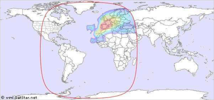
SATELLITE REACH COVERAGE FROM HOUSTON:
Westward Reach. Source: SatStar.net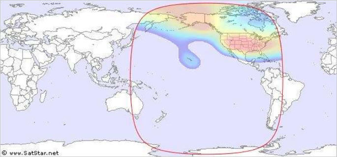
List of Satellites Within Reach of Houston (not an all-inclusive list):
| Satellite | Location | |
|---|---|---|
| SES AMC-11 | 229°E | 131°W |
| Echostar 5 | 231.1°E | 128.9°W |
| Telstar 7 | 231°E | 129°W |
| Horizons 1 | 233°E | 127°W |
| Galaxy 13 | 233°E | 127°W |
| Galaxy 14 | 235°E | 125°W |
| Galaxy 10R | 237°E | 123°W |
| EchoStar 9 | 239°E | 121°W |
| DirecTV 7S | 240.8°E | 119.2°W |
| Echostar 2 | 240°E | 119°W |
| Echostar 7 | 241.1°E | 118.9°W |
| Anik F-3 | 241.3°E | 118.3°W |
| Echostar 5 | 241°E | 119°W |
| AMC 16 | 241°E | 119°W |
| Satmex 5 | 243.2°E | 116.8°W |
| Solidaridad 2 | 244.1°E | 114.9°W |
| XM-4 | 245°E | 85°W |
| Satmex 6 | 247°E | 113°W |
| Wildblue 1 | 248.9°E | 111.1°W |
| Anik F-2 | 248.9°E | 111.1°W |
| Echostar 6 | 249.8°E | 110.1°W |
| Echostar 10 | 249°E | 110°W |
| Anik E-1 | 250.8°E | 109.2°W |
| Solidaridad 1 | 250.9°E | 109.1°W |
List of Satellites Within Reach of Houston - continued:
| Satellite | Location | |
|---|---|---|
| Echostar 8 | 250°E | 110°W |
| DirectTV 5 | 250°E | 110°W |
| Anik F-1 | 252.7°E | 107.3°W |
| AMC-18 | 255°E | 105°W |
| Satcom C4 | 255°E | 105°W |
| AMC 15 | 255°E | 105°W |
| Gstar 4 | 255°E | 105°W |
| Galaxy 6 | 256.2°E | 103.8°W |
| GE-1 AMC-1 | 257°E | 103°W |
| DirecTV 4S | 258.9°E | 101.1°W |
| GE4 AMC 4 | 259.0°E | 101°W |
| DirecTV2 | 259.4°E | 100.6°W |
| DirecTV 8 | 259°E | 101°W |
| DirecTV 9S | 259°E | 101°W |
| Galaxy 16 | 261°E | 99°W |
| Galaxy 4R | 261°E | 99°W |
| Immarsat 2F2 | 263°E | 97°W |
| Telstar 5 | 262°E | 98°W |
| Spaceway 3 | 265°E | 95°W |
| Galaxy 3C | 265°E | 95°W |
| DirecTV 5 | 266.6°E | 93.4°W |
| Telstar 6 | 267°E | 93°W |
| DirecTV 3 | 268.8°E | 91.2°W |
| Brazilsat B4 | 268°E | 92°W |
List of Satellites Within Reach of Houston - continued:
| Satellite | Location | |
|---|---|---|
| Galaxy 12 | 269°E | 125°W |
| Galaxy G-17 | 269°E | 91°W |
| Galaxy G-11 | 269°E | 91°W |
| Telestar 8 | 271°E | 89°W |
| GE-3 | 273°E | 87°W |
| XM-3 | 274.9°E | 85.1°W |
| XM-2 | 274°E | 86°W |
| GE-2 | 275.1°E | 84.9°W |
| SM-1 | 275°E | 115°W |
| Brazilsat B3 | 276°E | 84°W |
| GE 12 | 277°E | 83°W |
| IS SBS 6 | 279°E | 81°W |
| Anik E-2 | 279°E | 81°W |
| Galaxy 9 | 279°E | 81°W |
| Satcom C3 | 281°E | 79°W |
| GE 5 AMC 5 | 281°E | 79°W |
| Echostar 4 | 283°E | 77°W |
| Brazilsat B1 | 285°E | 75°W |
| Galaxy 3R | 286°E | 74°W |
| Horizons 2 | 286°E | 74°W |
| Galaxy 17 | 286°E | 74°W |
| DirectTV 1R | 287°E | 73°W |
| Nahuel 1A | 288.2°E | 71.8°W |
| GE 6 AMC 6 | 288°E | 72°W |
List of Satellites Within Reach of Houston - continued:
| Satellite | Location | |
|---|---|---|
| StarOne C-1 | 295°E | 65°W |
| Brazilsat B2 | 295°E | 65°W |
| Telstar 14 | 297°E | 63°W |
| Rainbow 1 | 298.5°E | 61.5°W |
| 277°E 83°W | 298.5°E | 61.5°W |
| Amazonas | 299°E | 61°W |
| Intelsat 9 | 302°E | 58°W |
| IS 805 | 304.5°E | 55.5°W |
| Inmarsat 3-F4 | 306°E | 54°W |
| IS 707 | 307°E | 53°W |
| Inmarsat 4-F2 | 307°E | 53°W |
| Intelsat IS 705 | 310°E | 50°W |
| IS 11 | 317°E | 43°W |
| NSS-806 | 319.5°E | 40.5°W |
| NSS-10 | 322.5°E | 37.5°W |
| Satcom C1 | 322.5°E | 37.5°W |
| IS 903 | 325.5°E | 34.5°W |
| IS 801 | 328.5°E | 31.5°W |
| Hispasat 1C | 329.8°E | 30.2°W |
| Hispasat 1D | 330.1°E | 29.9°W |
| IS907 | 332.5°E | 27.5°W |
| IS905 | 335.5°E | 24.5°W |